HPC
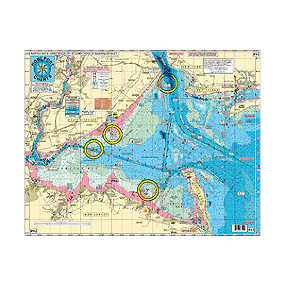
HPC 42 Raritan Bay and Ocean out 20 Miles of Jones Inlet, NY to Manasquan, NJ
HPC 42 Raritan Bay and Ocean out 20 Miles of Jones Inlet, NY to Manasquan, NJ
Couldn't load pickup availability
HPC 42 Raritan Bay and Ocean out 20 Miles of Jones Inlet, NY to Manasquan, NJ
Changed and Additional Buoys Added to Ambrose Channel and Ocean Front
NEW YORK - NEW JERSEY STATE LINE ADDED!
One Chart shows all Raritan Bay fishing grounds, channels and buoys, with on site GPS coordinates and all the Atlantic Ocean fishing grounds showing awesome bottom structure with the Mud Hole out to 20 miles.
Fishing Grounds on the Raritan Bay Side: Great for Kayaking! Gong Grounds, Tin Can Grounds, 14 ft Channel, Fluke Superhighway, Borrow Holes, West Bank, Miller's Field, Staten Island Flats, High Grounds, Romer Shoal, Flynn's Knoll, Great Kills Flats, Alandale Grounds, Dental Works, Red Bank, Point Comfprt Shoal, Great Bed Reach, Keyport Flats, Keansburg Channel, Monument Grounds, Spermaceti Cove, and many more.
Fishing Grounds on the Ocean Side: Scallop Ridge, Clam Beds, Chicken Canyon, Shrewsbury Rocks, Acid Waters, The Farms, Tarpon Lump, England Bank, Annex, Augies Lump, Klondike Bank, Manasquan Ridge, East Lump, Shark Ledge, Humpty Dumpty, "EN" Rocks, and many more.
Artificial Reefs shown: Sandy Hook Reef-Sea Girt Reef-Axel Carlson Reef
Wreck with DGPS coordinates: Joe's Wreck, Duke, Lido, Rum Runner, USS Turner, Sandy Hook Wreck, Mohawk, Bald Eagle, 3 Sisters, Mud Hole Wreck, Goulandris, Dry Dock, Blue Boy II, Geralda, Logwood, Hankins, Maine, Glory, Caddette, Arundo II, Immaculata (Irma), and many more.
*Laminated-waterproof
*Color coded depth and Contour Curve lines
*Lighted, unlighted buoys and range markers are shown
*LAT/LON for buoys and lights noted
*Boat Ramps
*All depths in feet
Joins Charts:
#3 All Canyons Hudson to Norfolk
#6 Mud Hole Chart Sandy Hook to Ocean City MD
#7 Manasquan to Great Egg Inlet out 20 miles
#16 Inshore Shark River- Manasquan- Barnegat Inlets
#12 Canyon Cahrt-Hudson to the South Poormans
#22 ICW Manasquan Inlet-Barnegat Bay-Manahawkin Bay

Have a question about a product or destination?
Call on us for 40 years experience in charts, navigation, and maritime history.
Call +1-267-773-7858 or Email sales@pilothousecharts.com